

Satellite Map
Route Planner

Description of Satellite Map: Route Planner
GPS Earth Maps Live Navigation is an application designed for users seeking efficient navigation and exploration capabilities. This app provides real-time GPS navigation, satellite imagery, and various map types, making it a versatile tool for travelers and explorers. Available for the Android platform, users can easily download GPS Earth Maps Live Navigation to enhance their journey.
The app features a user-friendly interface that allows users to navigate seamlessly while receiving clear, concise voice instructions. This voice navigation feature facilitates hands-free travel, enabling users to focus on the road rather than on their devices. By utilizing GPS technology, the app ensures that users can find their way to their desired destinations with ease.
One of the app's significant functionalities is its ability to display multiple map views. Users can choose from different perspectives, including normal view, night mode, and terrain maps. This variety allows travelers to select the most suitable map type based on their immediate needs and preferences. The availability of real-time traffic alerts further enhances the navigation experience, providing timely updates on road conditions and potential delays.
Route planning is another essential aspect of GPS Earth Maps Live Navigation. Users can efficiently plan their routes by entering their starting point and destination, with the app calculating the shortest and most efficient paths. This feature is particularly useful for those who seek to optimize their travel time and avoid congested areas. The app also enables users to save their favorite routes for easy access during future journeys.
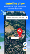
For those interested in exploring new locations, the app offers detailed satellite images of renowned landmarks and tourist destinations. Users can effortlessly search for specific places, gaining insight into their surroundings before arriving. The ability to view GPS-tagged buildings and cities allows for a more informed travel experience, ensuring that users are aware of their environment.
Additionally, the app provides users with their precise GPS location, including latitude and longitude coordinates. This feature is beneficial for outdoor enthusiasts and explorers who may need to share their location with friends or family. By pinpointing their location on a satellite map, users can gain a better understanding of their surroundings, which can be especially helpful in unfamiliar areas.
The GPS speedometer is a practical tool included within the app, allowing users to monitor their speed while driving. This feature not only helps users stay within speed limits but also includes alerts for over-speeding, promoting safe driving practices. The speedometer enhances the overall driving experience, ensuring that users can focus on their journey without unnecessary distractions.
Real-time updates on global traffic conditions are integrated into the application, allowing users to stay informed about their route. This feature helps travelers make informed decisions about their travel plans, enabling them to adjust their routes based on current traffic situations. The app provides a clear view of streets and nearby locations, ensuring users remain aware of their surroundings at all times.
The Earth Maps feature enhances the navigation experience by providing a comprehensive overview of the user's current location. Users can easily discover street addresses and navigate through their environment. This capability is particularly useful for individuals who may be navigating through busy urban areas or unfamiliar regions.
In terms of measuring angles, the app includes a precise angle of inclination feature. Users can measure both vertical and horizontal levels quickly, which may be advantageous for various applications, including outdoor activities or construction projects. This tool ensures accurate readings and aids users in understanding their surroundings better.
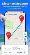
Users can also calculate the distance between two locations using the app, which can be essential for planning trips or determining travel times. The straightforward calculation feature allows for quick assessments, making it easier to manage travel logistics.
GPS Earth Maps Live Navigation is a comprehensive solution for those looking to navigate efficiently and explore their surroundings. The combination of voice navigation, real-time traffic alerts, and multiple map views ensures that users have the tools they need to reach their destinations safely and effectively. With the ability to save preferred routes, monitor speed, and access detailed satellite views, this app stands out as a valuable resource for travelers and explorers alike. By downloading GPS Earth Maps Live Navigation, users can enhance their navigation experience and embark on their journeys with confidence.


